Hadrian's Wall: Archaeologists uncover ‘unknown part’
We use your sign-up to provide content in ways you’ve consented to and to improve our understanding of you. This may include adverts from us and 3rd parties based on our understanding. You can unsubscribe at any time. More info
Work on Hadrian’s wall — Britain’s largest Roman archaeological feature at 73 miles long — began AD 122, with the defensive fortification marking the northernmost border of the Roman empire for some two decades. In AD 142, having made further gains north of Hadrian’s Wall, the Romans built a second defensive line, a turf-on-stone fortification called the Antonine Wall that ran across from what is today the Firth of Forth to the Firth of Clyde. A mere eight years later, however, this second wall was abandoned following pressure from the Caledonian tribes, with the empire drawing its frontier back south to Hadrian’s Wall.
While much archaeological research has been undertaken on the region between these two walls, such has predominantly focussed on a Roman perspective — looking at the camps, forts, roads and walls the empire’s forces used to control northern Britain.
The new study, however, is part of an effort to better understand the lives of the indigenous communities that dwelled in this frontier region.
Paper author and archaeologist Dr Manuel Fernández-Götz of the University of Edinburgh said: “This is one of the most exciting regions of the Empire, as it represented its northernmost frontier.”
Furthermore, he added, “Scotland was one of very few areas in Western Europe over which the Roman army never managed to establish full control”.


In an ongoing project, Dr Fernández-Götz and colleagues are studying the ancient history of the swathe of Britain that runs some 25 miles south of Hadrian’s Wall to 25 miles north of the Antonine Wall — or, in other words, from Durham to the southern Scottish Highlands.
The first part of their work focussed on the the region around Burnswark hillfort, in Scotland, which lays claim to being the site with the greatest concentration of Roman projectiles ever found in Britain, and is a testament to the firepower at the disposal of Rome’s legions.
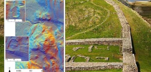
Following that, the team expanded further beyond Burnswark, studying laser-scanning, or “Lidar”, data from the surrounding 580 square miles.
Even though part of this area had been extensively studied in the past, the researchers were able to discover 134 previously unrecorded Iron Age settlements — bringing the total number known from the region to more than 700.
———


Although many of the larger sites in the study area were already known to archaeologists, the survey’s revealing of many small farmsteads represents a useful finding.
These kinds of settlements better reflect the conditions within which the majority of the indigenous population would have lived.
Furthermore, the researchers noted, the fact that the sites were dispersed quite regularly across the ancient landscape — with dense clusters in places — speaks to a highly organised settlement pattern.
Paper author and archaeologist Dr Dave Cowley of Historic Environment Scotland said: “The important thing about the discovery of many previously unknown sites is that they help us to reconstruct settlement patterns.
“Individually they are very much routine, but cumulatively they help us understand the landscape within which the indigenous population lived.”
DON’T MISS:
NASA warns underwater volcano full of SHARKS has erupted [ANALYSIS]
Energy lifeline: ‘No option off table’ to tackle cost of living crisis [INSIGHT]
Jeff Bezos backing £300m British project to create limitless energy [REPORT]

With their initial study complete, the researchers are now studying some of the more notable discoveries in greater detail using other geophysical surveying techniques.
They are also looking to apply radiocarbon dating to form a more complete picture of when the settlements were occupied.
From this, they said, they hope to gain a clearer understanding of how life changed before, during and after the Roman occupation of northern Britain.
The full findings of the study were published in the journal Antiquity.
Source: Read Full Article


