News surfaced recently of a fitness tracker app reportedly revealing the location of US military bases around the world.
The Global Heat Map, published by GPS tracking company Strava, unveiled mysterious activity from the likes of Somalia to Yemen.
But, in the most bizarre of “discoveries” to date, one viewer claims to have found an underground Government base in the South Pole.
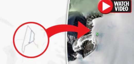
Tyler Glockner – of YouTube channel SecureTeam10 – uploaded footage using the software, appearing to show heat signatures from an isolated location in Antarctica.
“We have a new area of Antarctica that was discovered where – in the middle of nowhere – we had one of these heat maps,” he said.
“We can obviously see the outline of what looks like a multi-level building, which obviously people who are wearing tracking devices – likely Government employees – have been walking around every single day.”
When the clip switches to Google Earth of the same area, however, nothing can be seen apart from mountains and snow.
There is a man-made runway and camp some seven miles away from the “building”, but nothing in its exact coordinates.
“That leads me to believe is that whatever we are seeing in this heat map, it is definitely underground,” Tyler adds.
“You can see some of the lines here are overlapping which signifies to me there are definite multiple levels.
“While there are many publicly known camps or bases or stations scattered around Antarctica, I firmly believe there is more of a mystery there, there are things underground which we are not being told about.”
More than 100,000 people have seen the clip since it was posted yesterday (February 4).
“Awesome video, I would love to know what they are hiding down there,” one user commented.
Another added: “The more we look, the more evidence we find of highly advanced civilisations that were here way before us.”
But a third pointed out: “If it was underground there would be no GPS signal and therefore no location tracking.”
Source: Read Full Article


