Save articles for later
Add articles to your saved list and come back to them any time.
1 of 1
TC Ilsa to make landfall tonight
Welcome to WAtoday’s live coverage of Severe Tropical Cyclone Ilsa, expected to make landfall tonight as a category 5 system just east of Port Hedland in Western Australia’s Pilbara region.
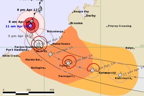
The Bureau of Meteorology is predicting the cyclone will cross the coast around midnight near Pardoo and travel south-east across the Sandy Desert towards De Grey and Telfer.
The cyclone will track inland.Credit: BOM
People staying in remote communities, mining camps and cattle stations in the system’s path have been encouraged to evacuate, or bunker down in cyclone-proof buildings.
Experts are predicting wind gusts of up to 280 kilometres an hour, powerful enough to lift caravans, boats and trailers.
Heavy rainfall and flash flooding is also expected, with between 200 and 400 millimetres of rain possible where Ilsa crosses the coast.
A red alert, which requires people within the warning zone to remain indoors, is expected to be issued this afternoon.
Understanding cyclone tracking and categories
Ilsa is ‘really packing a punch’
Cyclone Ilsa is about 250 kilometres to the north of Port Hedland, with gusts of 230km/hr recorded near the centre. A red alert is expected to be issued between 3pm and 4pm WST.
It has been 10 years since a cyclone of this strength has crossed the Western Australian coast, and widespread and very significant impacts are expected.
The Bureau of Meteorology’s Todd Smith said the system was “really packing a punch” as it heads towards the coast between Broome and Port Hedland.
“Communities in those coastal areas hopefully are already hunkered down, ready to ride this one out, and hopefully communities inland are finalising their preparations,” he said.
Damaging and destructive winds will develop throughout this evening, with winds at the core of the cyclone as it crosses the coast in excess of 270km/hr predicted.
The Bureau of Meteorology warned winds of that magnitude could lift caravans, cars and boats into the air, and damage homes and buildings.
Department of Fire and Emergency Services commissioner Darren Klemm said multiple evacuation centres had been opened.
“Those people whose plan is to evacuate, they need to do it. You can’t wait any longer to remove yourself from being in the yellow alert area,” he said.
“Later this afternoon, around about 3pm to 4pm, that yellow alert will be upgraded to red alert.”
He said Ilsa was likely to be upgraded to a category 5 before it crosses the coast.
“Because it’s such a fast moving cyclone, the strength of the cyclone will be maintained as it moves inland.”
The tropical cyclone watch warning area extends across the Great Sandy Desert.
Rainfall of up to 300mm as the cyclone tracks across the state into central Australia is predicted.
An expensive exercise – closing the port of Port Hedland
Tropical Cyclone Ilsa’s advance has closed the port of Port Hedland, with bulk carriers sailing out north-west, away from the storm front.
The world’s biggest bulk export port, which ships tens of millions of tons of mostly iron ore every month, began winding down its operations on Tuesday, as Ilsa was forming in the ocean north of Broome.
Berths and anchorages were cleared by Wednesday and on Thursday, as news came that Ilsa was due to reach category 5 strength before making landfall just north, Pilbara Ports Authority announced the port had been closed.
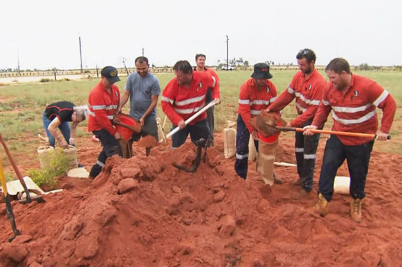
Volunteers in Port Hedland help get the town ready.Credit: Nine News Perth
Ilsa is predicted to make landfall on Thursday night before weakening as it heads inland across Friday, eventually passing Kiwirrkurra community in the Gibson Desert by Saturday and heading into the southern NT.
More than 38 million tonnes of iron ore passed through Port Hedland in February, according to Pilbara Ports Authority, which at today’s price of US$115 per tonne means upwards of $148 million flows through the port every day.
That makes closing the port an expensive, but necessary, exercise.
‘This is a big one’
Ilsa will now likely cross the coast as the highest category of storm about 150 kilometres to the northeast of Port Hedland, near Pardoo Roadhouse, late on Thursday rather than early Friday.
“Any houses that aren’t built to code are going to suffer extensive damage … fortunately it looks like the system is going to cross in a relatively unpopulated part of the coast,” the Bureau of Meteorology’s Todd Smith said.
Manager of the remote Pardoo fuel station, Will Batth, said he was planning to stay and hunker down with a colleague once the storm hit.
“We haven’t had any as strong as this in many years. This is a big one,” he said.
“(But) there’s no point in worrying. I can’t stop it.”
Evacuation centres have been opened in South Hedland, Newman, Marble Bar and Nullagine.
Abnormally high tides, flooding, destructive winds and up to 300mm of rain are forecast.
AAP
TC Ilsa to make landfall tonight
Welcome to WAtoday’s live coverage of Severe Tropical Cyclone Ilsa, expected to make landfall tonight as a category 5 system just east of Port Hedland in Western Australia’s Pilbara region.
The Bureau of Meteorology is predicting the cyclone will cross the coast around midnight near Pardoo and travel south-east across the Sandy Desert towards De Grey and Telfer.
The cyclone will track inland.Credit: BOM
People staying in remote communities, mining camps and cattle stations in the system’s path have been encouraged to evacuate, or bunker down in cyclone-proof buildings.
Experts are predicting wind gusts of up to 280 kilometres an hour, powerful enough to lift caravans, boats and trailers.
Heavy rainfall and flash flooding is also expected, with between 200 and 400 millimetres of rain possible where Ilsa crosses the coast.
A red alert, which requires people within the warning zone to remain indoors, is expected to be issued this afternoon.
1 of 1
Most Viewed in National
Source: Read Full Article


