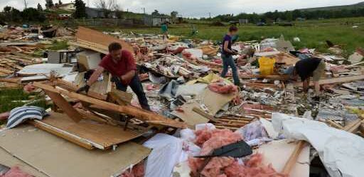
The La Niña weather pattern that has persisted for nearly two years looks to continue into the summer months, according to the Climate Prediction Center. Just like in the winter, when La Niña can impact our snow and cold, in the spring, La Niña can impact our severe weather and temperatures.
La Niña is part of the weather phenomenon known as ENSO, or El Niño Southern Oscillation. This refers to whether or not the sea surface temperatures of the equatorial Pacific Ocean are running cooler (La Niña) or warmer (El Niño) than average — or near-normal, which is known as ENSO Neutral.
We have been in a La Niña since mid-2020, and the current forecasts are showing that La Niña conditions will persist through this summer with a trend towards neutral conditions. It’s possible that weak El Niño conditions develop by the end of this year, but it’s more likely that we’ll stay near-neutral than anything.
As we head deeper into the spring months, we will start to see more severe weather unfold nearby. Here’s a look at when any form of severe weather (hail, tornados, damaging winds) begins to work its way into the state of Colorado.
By the end of April, some severe weather is possible in far eastern Colorado. By the end of May, we start to get more frequent severe storms and, by the middle of June, we’re in full-fledged severe weather season.
With the likelihood of La Niña continuing through July and August, how will it impact our severe weather?
As we’ve already seen in portions of the deep South, this has been a very active start to the severe weather season. During spring in a La Niña pattern, what tends to happen is the jet stream ends up cutting through the northern third of the U.S. During the spring, when temperatures are getting warmer toward the South, the temperature gradient of air masses that are created turns into a recipe for severe weather.
Eventually, the jet stream will begin moving further north, but due to the La Niña, it might not retreat as far north as it normally does this time of the year.
With the jet stream not retreating as far north as normal during these next few months, we’ll have cold air nearby which will allow for stronger cold fronts to push into the warming and more humid South. The collision of these air masses aids in spawning severe weather outbreaks and this setup allows for that to happen more often.
There is not a drastic correlation when talking about the impacts of severe weather during a La Niña spring but there are some notable points that line up with the thinking mentioned above. Nationally, some of the most active severe weather seasons in the last 30 years happened during La Niña years: 2011, 2008, 1998 and 1995 all brought big severe weather impacts while La Niña was ongoing.
Out of the top 10 years with the most severe thunderstorm and tornado warnings in Colorado, seven of those years were La Niña years and three of them were El Niño years.
Also, something to note, some of our top producing severe weather years have all happened since 2000. When we look nationally, during a La Niña, there’s a severe weather bullseye across Texas, Arkansas and Oklahoma.
For Colorado, there is no damning evidence that we’re going to have a notably heightened severe weather season due to the continuing La Niña, but there are differences that we can spot.
Severe weather tends to be slightly suppressed statewide when a El Niño is present. While Colorado is not multiple nodes away from what is normal in a La Niña pattern, we do trend toward the more frequent side of things when talking about tornadoes. Mountain locations and southern Colorado tend to have slightly more hail concerns during a La Niña pattern.
Temperatures and precipitation could also be impacted by this continuing La Niña, but the effects aren’t as notable as they are in the winter months. In the warmer months, ENSO tends to have more impacts on the hurricane season than anything else. With that said, long-range forecasts from April through June are showing signs of being drier and warmer across all of Colorado.
What the above images show is that the time period between April, May and June is expected to be a half-inch to an inch drier than normal. At this same time, we could expect temperatures to be near a degree warmer than normal.
Of course, time will tell but when looking at previous severe weather years, previous La Niña years and long-range forecasts, there’s no reason to heavily doubt the possibility that this severe weather season may be a bit more active than normal in and around Colorado this year.
Just like folks do along the coast ahead of hurricane season, it’s time to prepare for severe weather. Hail and tornadoes are no strangers to Colorado. Damaging winds, too.
Preparing now for what these threats bring will make action time much more smooth.
Source: Read Full Article


