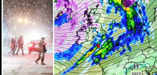
Ontario: Houses covered in ice near Lake Erie
We use your sign-up to provide content in ways you’ve consented to and to improve our understanding of you. This may include adverts from us and 3rd parties based on our understanding. You can unsubscribe at any time. More info
Gale-force winds with snow and rain are poised to batter Scotland and the north of England as the UK heads towards storm season. The latest weather maps from WXCharts show a low-pressure system heading straight for the UK from the Atlantic in the New Year, threatening a return to the wintry conditions seen before Christmas.
The mercury could dip as low as 0C or further as a result of the system which is poised to bring blizzards to northern Scotland.
Jim Dale, a global meteorologist, told Express.co.uk: “This looks like a deep Atlantic low-pressure system, bringing wintry conditions to Scotland, the north of England and Northern Ireland.
“If it results in what we were seeing at this moment in time, then there will be blizzards over the Highlands and Grampians. It’s a step back to the wintry conditions we saw before Christmas.”
Mr Dale added that if the front continues to track as predicted, it will be colder everywhere with winds from gale to severe gale force, threatening 50 to 70mph gusts across northern areas and possibly 40 to 50mph in the south.


He said temperatures for January 8 are tracking towards 0C or maybe lower in the Scottish Highlands and 5C to 6C in other areas, though in the wind it will feel colder in the Manchester area.
On the low-pressure system, he continued: “It’s too far away to be certain at this time, but it’s one that needs watching.
“We’re heading into storm season 2023, though this is early days compared to last year’s storm season when we saw six to seven storms in January and February.
“It could be a named storm with the potential for destruction and disruption, but we’ll have to wait and see. It’s early days.”
READ ABOUT FREE RANGE EGG RULES GETTING BINNED


Mr Dale said: “It’s not a revisit of the Troll from Trondheim. It’s a typical, deep Atlantic low, tracking to the north of Scotland.”
Northern parts of the UK were blasted by a sub-zero weather front, dubbed the Troll from Trondheim, earlier this month.
Meanwhile, forecasters have issued an amber weather warning over heavy rain for part of Scotland on Friday (December 30).
The Met Office alert, which covers Dumfries and Galloway and the Scottish Borders, says 40-50mm of rain is expected quite widely. It warns fast flowing or deep floodwater is likely, causing danger to life.
DON’T MISS:
Woman run over by Tube train ‘could have died 10 times’ after injuries [REVEALED]
Mum left ‘flustered’ after DNA tests threaten to uncover family secret [LATEST]
UK urged to impose new Covid restrictions on China [REPORT]

The alert is valid from 3am until midday on Friday and also warns of the potential for difficult driving conditions and delays or cancellations to train and bus services.
The Met Office said the deadly bomb cyclone which has sent temperatures plunging in the US is also causing the UK to experience wet and windy weather.
The forecaster has updated its yellow weather warning for heavy rain on Friday which now runs from midnight on Thursday rather than 3am on Friday and expires at 2pm rather than 6pm on December 30.
The warning covers Central Scotland, Tayside and Fife, south west Scotland, Lothian and Borders and Strathclyde.

A yellow warning of snow and ice covers northern Scotland, apart from Orkney and Shetland, from midnight on Thursday until 9pm on Friday.
Met Office Meteorologist Simon Partridge said the wet and windy weather was being caused by the bomb cyclone in the US.
He said: “The UK weather is going to remain unsettled with further spells of wet and windy weather due to the strengthening of the jet stream because of the weather in the US.”
Mr Partridge added the impact on the UK would be “nowhere near” as significant as it was on the US.
He said: “The effect it’s having on the UK is nowhere near as dramatic because that system has brought up a lot of cold air further south, across the US.”
Indeed, the cyclone is only having an effect on the UK due to its impact on the North Atlantic jet stream.
Mr Partridge said: “What effect (the bomb cyclone) has had is to strengthen the jet stream, because the jet stream is basically driven by temperature differences. So the starker the difference in temperature between the northern edge of it and southern edge, the stronger the jet stream becomes.”
He said the knock-on effect for the UK is spells of wet and windy weather over the next seven to 10 days.
Thursday is forecast to be colder than Wednesday, with sunshine and some heavy showers in northern Scotland and western England, as well as a risk of hail and thunder.
Mr Partridge said Thursday will be a “cooler feeling day”, but “still rather windy and with showers” across the UK.
Friday to Sunday is forecast to be unsettled, with snow over the Highlands, showers and rain in southern England with frosts and fog overnight.
He added: “And then on Friday, we’ll see another spell of wet, windy weather with milder temperatures and then similar sorts of patterns to that over the next few days. So the general sort of knock-on effect of the weather in the US is that in general the UK is going to be a little bit milder than it would normally be at this time of year.”
Source: Read Full Article

