Weather: Met Office issues yellow warnings for storms and snow
We use your sign-up to provide content in ways you’ve consented to and to improve our understanding of you. This may include adverts from us and 3rd parties based on our understanding. You can unsubscribe at any time. More info
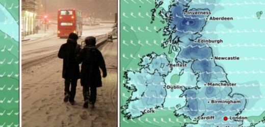
According to Netweather forecaster Nick Finnis, the “cold and showery” airstream will bring with it “significant accumulations” of snow, strong wind, hail and thunder. Weather forecaster WXCharts has predicted that wind chill temperatures will be below 0C across the UK, with Scotland seeing lows of -8C. Manchester and Newcastle will feel as cold as -4C.
By tomorrow, Scotland will see actual minimum temperatures of -8C, WXCharts has forecast.
It has also predicted approximately 0.1inches (0.3cm) of snow per hour across much of the UK, with higher parts of Scotland seeing as much as 10inches (25cm) in total.
The Met Office’s yellow warning for snow and ice will come into force across parts of Scotland, North West England and North East England from 8pm today until 9.30am tomorrow.
It warned that “further wintry showers, with snowfall mainly on hills, will lead to icy surfaces, perhaps making for difficult travel conditions tonight.”


This could result in longer journey times, the forecaster said.
It added: “Further areas of rain, sleet and hail, with snow mainly at elevations above around 200-300 metres, are likely to affect many areas this evening.
“These will be heavy in places, perhaps bringing 2-5 cm of snow to some of the higher routes across the Pennines and Scotland.
“Beyond midnight, showers will become less widespread and will fall increasingly as rain or sleet away from some higher routes and parts of northern Scotland.


“However as temperatures fall, icy stretches are possible more widely, especially on untreated surfaces.”
Mr Finnis said the snow could settle “even at lower levels”.
He said: “A cold and showery polar airstream has moved in from the west across many areas overnight behind a cold front clearing SE England at breakfast time.
“Frequent snow showers are piling in across Scotland, N. Ireland and northern England…settling even at lower levels.
DON’T MISS:
FOURTH storm to hit battered Britain today [REPORT]
Storm Gladys: When will snow barrage hit the UK? [ANALYSIS]
Cold Weather Payment scheme explained – are you eligible? [INSIGHT]

“Some significant accumulations possible over the Highlands, drifting in the strong wind.
“Hail and thunder may also accompany the heavier showers, particularly in the west.”
The forecaster added: “Further south, cloud and outbreaks of rain, locally heavy, across much of southern England, Midlands and East Anglia at breakfast time, will clear east through the morning.
“Following will be brighter but showery conditions, already across Wales and SW England, spreading east across all parts by late morning.

“Showers will be wintry in nature, with a mixture of sleet, hail and hill snow and perhaps the odd rumble of thunder in the heavier showers.
“A band of more organised sleet and snow showers along an occluded front looks to sweep southeast across N. Ireland and northern England later this evening, giving a covering in places, wintry showers continuing across northern and western Scotland and towards the north of N. Ireland this evening and overnight.
“Elsewhere, any wintry showers fading to leave a dry but cold night with clear spells, allowing a frost locally in rural areas, with some icy patches possible where showers have fallen.”
Source: Read Full Article

