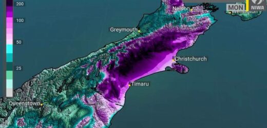
The rough weather forecast for many parts of the country is beginning to set in, with two days of persistent rain expected in Canterbury, which could cause rivers to burst their banks.
MetService meteorologist Tom Adams says the Nelson-Tasman region has been particularly hard hit so far.
“We’ve seen some stations – particularly around the Takaka Hill region – that have seen over 100 millimetres in the last 12 hours. Canterbury, on the other hand, the red warning for the rain over there only started at 3pm today and we’re 30 or so millimetres falling in the Canterbury stations, but that’s very small change compared with what they’re expected to see over the next two days.”
MetService has forecast 200 to 300mm of rain could fall on the Canterbury High Country and foothills.
Adams says there could also be thunder and hail in the North Island.
Meanwhile, Civil Defence agencies in the South Island are on standby, and the Transport Agency is also prepared for possible flooding.
Shaun McCracken – the flood controller for the area from Hinds to Kaikoura – says the bulk of the rain will be from this afternoon onwards.
Rivers of concern include the Ashley, Selwyn, Ashburton, Opihi and Orari rivers along with the tributaries that flow into those rivers.
McCracken says river flows will be highest on Sunday and Monday.
Niwa is forecasting a rapid increase in river flows across Canterbury.
There have been heavy thunderstorms in the upper North and upper South Island today as a series of active fronts and troughs pass over the country.
MetService reported 1233 lightning strikes in 120 minutes.
National Emergency Management Agency communications manager Anthony Frith said when the rough weather set in, it could be serious.
“This has the potential to be quite a serious flooding event for some regions, and people need to take it seriously. Listen to the advice and instructions of their local authorities and local Civil Defence groups, and listen to the radio and other media. It’s really important that people stay away from floodwater, please drive only if absolutely necessary.”
MetService has also warned that a combination of king tides and strong northwesterlies may bring coastal inundation to Auckland this weekend.
Nelson’s emergency personnel say rain has been falling this morning, but it has not a problem so far.
West of Motueka, heavy rain is forecast to continue until 8pm tonight, while for the Richmond Ranges, rain should continue until 11pm.
The Transport Agency says it is prepared for possible flooding and spokesperson Tresca Forrester has urged South Islanders to take care on the roads.
“We are resourced up for the weekend and we’ve put plans in place if we do end up closing roads in particular, putting detours in place if need be. But it’s all dependent on how heavy the rain comes and where it comes in. All we can do is be prepared and ready to respond.”
Source: Read Full Article


