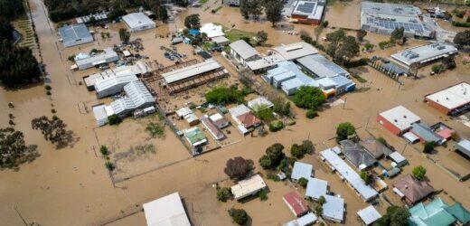
Our live coverage of the extreme weather is free for all readers. Please consider supporting our journalism with a subscription.
The Mitchell Shire Council voted unanimously two years ago to abandon a proposed levee wall along the banks of Goulburn River in Seymour, which would have protected hundreds of homes and businesses from the devastating impact of the current flood.
The $20-25 million levee project was fully planned and costed and had attracted $5.8 million in state and federal government grants when the council dumped it in June 2020 amid community concerns over the loss of river views, access and habitat and spending priorities.
The flooded centre of Seymour last Friday.Credit:Jason South
Seymour was subsequently identified, along with the town of Shepparton, as national priorities for flood mitigation by the Insurance Australia Group (IAG), which is calling for greater government investment to protect regional communities located on flood plains.
“I don’t think you will find a single person who works in flood plain management who thinks there is enough money being spent on mitigation measures,” IAG peril and climate risk analyst Andrew Dyer told The Age.
“It is frustrating to see there is continual underinvestment in flood mitigation in this country.”
In the early hours of Friday morning, the Goulburn River peaked at 8.26 metres in Seymour, a level not recorded since 1916, and an estimated 300 properties were inundated. As the water subsides and residents return to their homes, heavy rain forecast for later this week is likely to bring further flooding.
Locals survey the damage on the Goulburn Valley Highway in Seymour last week.Credit:Jason South
Dyer said the national priority list, prepared by consultants Rhelm for IAG, was drawn from towns prone to flood damage and where a feasible engineering solution existed to mitigate the likely impact. The other towns shortlisted as national priories are Narrabri, Lismore and South Tweed in NSW and Innisfail, Rockhampton and Dalby in Queensland.
The proposed solution for Shepparton and neighbouring Mooroopna, where floodwater from the surging Broken and Goulburn rivers has affected an estimated 4000 properties, is a 20-year-old plan for a series of levees and the creation of a floodway in eastern Mooroopna. It is estimated to cost $47.7 million.
The proposed solution for Seymour is simpler and more advanced. It would have involved a single, 4.2 kilometre earth levee, rising to a height of 4.3 metres, designed to withstand the volume of floodwater which last week inundated the commercial heart of the town and nearby residential streets.
A preliminary design for the levee was first presented to the council in 2009 and developed over a decade with input from economic, ecological archeological and cultural heritage consultants.
A 2015 analysis prepared for the council accurately predicted that a once-in-a-century flood – flooding at a level last recorded in Seymour in 1974 – would impact about 400 properties in the town and inundate 360. According to the analysis, the levee would protect these properties and the resultant increase in land value would underpin a benefit-cost ration of 2.5 to 1.
In September 2019, the Mitchell Shire Council voted to consult more widely with the community.
On June 29, 2020, a week before the shire headed into its long COVID lockdown, the consultancy process came to an abrupt halt at a council meeting conducted by video.
Not one councillor spoke in favour of the levee, which had become unpopular among residents, according to community surveys.
Police officers rescue residents from the flooding in Seymour last Friday.Credit:Jason South
Councillor Rhonda Sanderson, a Seymour resident, told the 2020 meeting that locals had expressed concern about losing their connection to the river and interfering with the natural flood plain and the disruption to koala and wallaby habitats.
She noted that there hadn’t been a “massive flood” since the Goulburn was dammed at Eildon in the 1950s and flood overlays over large parts of the town hadn’t stymied development.
“People who have bought property in flood overlay areas, similar to people who buy in bushfire management areas, are aware of the risk,” she said. “They have their own reasons for choosing to buy where they have.”
Fellow councillor Annie Goble told the meeting a levee would “butcher” the river and argued the money would be better spent refurbishing the Old Goulburn River Bridge.
A flooded street in Seymour last week.Credit:Liam Mannix
“The community currently accept the risk; that is the current risk as it stands. They accept that and are well prepared for a flood with appropriate insurance and flood action plans on the ready,” Goble said.
Mitchell Shire Mayor Bill Chisholm told The Age on Monday the council’s decision to ditch the levee was driven by community sentiment.
“The consultation found most respondents involved in the engagement believed the project was too expensive or unnecessary,” he said.
“[The] council determined that the implications and risks associated with the project were too high to warrant further progression.”
Dyer, a qualified hydrologist, described the Seymour levee as “fully designed, costed up and ready to go”. He said it was up to communities to balance flood mitigation with other considerations, but levees were a proven way of preventing flood damage.
“They reduce risk to property, they reduce risk to life and they reduce the economic harm of flood events,” he said.
“A sensible flood management strategy also includes sensible land use planning measures.”
The Morning Edition newsletter is our guide to the day’s most important and interesting stories, analysis and insights. Sign up here.
Most Viewed in National
From our partners
Source: Read Full Article


