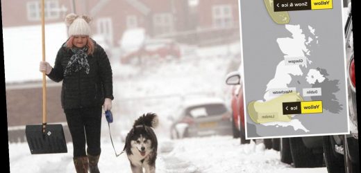
THE Met Office has warned that up to 20cm of snow is set to fall in parts of the UK this week as temperatures fall as low as -15C.
It comes as yellow weather warnings for ice remain in place across the south of England and parts of Scotland, with travel disruption expected through Sunday morning.
Areas including Wales, the West Midlands, Oxfordshire, and London could see snowfall in the coming days, while parts of the north are expected to get a heavy covering later in the week.
The cold snap is reportedly being caused by a "dense pool of cold air" from Scandinavia.
There is currently a weather warning for ice in place covering Wales, the Midlands, London, and the East.
The Met Office said that icy patches would be likely on untreated roads and pathways and would last into Sunday morning.
A second warning is in place across Orkney and the Shetland Islands, with ice expected to hit both and snow expected mainly across Shetland.
Roads and railways are also likely to be affected, with longer journey times expected for cars and buses.
Temperatures tonight are set to fall as low as -6C in England and -15 in parts of Scotland.
A total of 91 flood warnings and 243 less serious flood alerts are also in place across England amid rising river levels brought on by heavy rains.
The warnings are concentrated mostly in the Midlands, the East, and South Yorkshire, while the alerts are spread across the Southwest, South, East, and Midlands.
Speaking to the Star, Met Office meteorologist Simon Partridge said: "We've got this band of rain sleet and snow that's moving across much of England and Wales through today. That is a real messy mix."
He added that conditions are set to get even "more interesting as we go into Tuesday and the middle of the week".
He said that a "much heavier" band of rain moving in overnight on Monday would "quickly turn to snow as it bumps up against cold air" on Tuesday.
He said that Wales and the north of England could see "pretty much anywhere" between 1cm and 5cm of snow in low areas and between 5cm and 10cm on higher ground.
He also said that the highest areas of the country could see up to 20cm of snow, meaning there could be some disruption on Trans-Pennine routes.
Source: Read Full Article


