Save articles for later
Add articles to your saved list and come back to them any time.
Winter across most of Australia is likely to be warmer and drier than average during the day this year, with clearer skies increasing the likelihood of sporadic overnight cold snaps.
The return of the El Nino weather pattern, which reduces winter and spring rainfall across most of Australia, is not yet confirmed, but the Bureau of Meteorology (BOM) says there is a 50 per cent chance of this being an El Nino year.
Three-year-old Oriane plays in the autumn leaves at a park in Melbourne’s eastern suburbs.Credit: Joe Armao
The BOM’s most recent forecasts show that winter in 2023 will be drier than average for much of Australia, with warmer than average daytime temperatures. Night temperatures are also expected to be warmer than average, except for inland, eastern and central Australia.
“We are confident that maximum temperatures will be warmer than average for most, if not all, of the country,” Weatherzone meteorologist Joel Pippard said.
Two climate drivers could have an influence over Australia: the El Nino Southern Oscillation and the East Indian Dipole. Australians are familiar with the El Nino cycle over the Pacific Ocean – it’s one of the most important drivers of unusual weather over the entire globe. For most of Australia, El Nino brings dry weather, while its “sister” climate driver La Nina is wetter.
La Nina to El Nino outlook.Credit: Aresna Villanueva
This winter, the Australian region is also likely to see a “positive” East Indian Dipole, similar to El Nino but occurring on the western side of Australia, with moisture moving from the region around Indonesia and spreading towards southern Africa.
During a damp year, winter cold fronts drag moisture across Australia and bring rain to areas west of the Great Dividing Range. But a “positive” Indian dipole makes these less likely to occur, and sometimes stop these cold fronts completely.
“This leads to clearer skies, more sunshine during the day, and warmer days,” Pippard said.
Clearer skies will also mean occasional cold nights and accompanying frost.
There are some exceptions to this drier weather, including on the NSW coast, thanks to warmer oceans in that region and far north Queensland.
Warmer seas generate more intense storms and El Nino is likely to cause hot, dry conditions in Australia.Credit: Coral Expeditions
Climate change continues to shape Australian and global climates. In April 2023, the global sea surface temperature was the highest on record, according to BOM data, while Coral Sea surface temperatures were the second highest.
The Australian continent warmed by about 1.47 degrees between 1907 and 2021.
There has also been a trend towards a greater proportion of rainfall from high-intensity but short storms, especially across northern Australia. Southern Australia has had a 10 to 20 per cent reduction in cool season rainfall in recent decades.
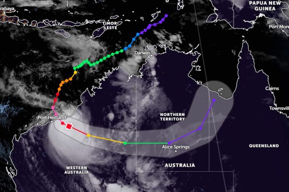
This year, April rainfall was well above average over central and north-western parts of Australia, which were affected by Cyclone Ilsa, but below average for parts of Western Australia, south-east Queensland and southern Tasmania.
A weather map showing the path of Cyclone Ilsa.Credit: Zoom.Earth
To declare an El Nino season this year, four conditions would need to be met. The first two – warmer ocean waters accumulating near South America, and international modelling forecasting it will occur – have both taken place.
The other two conditions have not yet been met: a certain level of air pressure difference between Tahiti and Darwin over three months and equatorial trade winds – which are currently close to average – would need to weaken.
Get to the heart of what’s happening with climate change and the environment. Our fortnightly Environment newsletter brings you the news, the issues and the solutions. Sign up here.
Most Viewed in Environment
From our partners
Source: Read Full Article


