More On:
polar vortex
Snow falls in Central Park in May for first time since 1977
Snow, wind and frigid temperatures will batter most of US this weekend
Polar vortex to bring chilling temps in latest sign Mother Nature has had it with us
Saturn’s moon has polar vortexes that can last 22 years
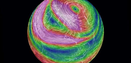
Rising temperatures in the stratosphere are sparking a “displacement” of the polar vortex — which could bring frigid temperatures and stormy weather to the Big Apple in the coming weeks, forecasters predicted.
The polar vortex, defined by the National Oceanic and Atmospheric Administration as “a large area of low pressure and cold air surrounding the Earth’s North and South poles,” was “extremely strong and robust” last year, bringing a mild winter, according to Accuweather senior meteorologist Bob Smerbeck.
“This year though, it’s not as strong and it’s being attacked by these big surges of warm air that are coming out of Eastern Asia,” Smerbeck said. “They come up northward and they start pushing up against that polar vortex, just start beating it down and pushing it around so to speak.”
The breakage is expected to send cold air blasting into Western Canada, the northern plains, and the Midwest, dipping temperatures there 15 to 30 degrees below normal late this month. The effect will be less significant, but still noticeable, in the Big Apple, he said.
“It may not be the brutal cold that they’re going to get up in the Midwest and northern plains, but people will notice that it actually is colder,” Smerbeck said.
Temperatures for the last week of January in New York City are expected to fall to 3 degrees below normal, and 5 degrees below normal in early February, according to Smerbeck.
High temperatures typically range from 38 to 27 degrees during that period, he said. Forecasters aren’t immediately predicting that any records will be broken.
“It takes time for what happens up in the stratosphere to work its way down into the jet stream level, so that’s why we’re probably seeing this delay in the cold for New York City until later in the month,” he said.
The polar vortex activity has the potential to bring storms to the city, Smerbeck said.
One of those storms is expected to roll in around Jan. 12, he said.
But for now, he said, rain is the best bet for the city.
“We don’t have that real cold air yet,” he said. “It’s going to take a while to develop.”
Sudden stratospheric warming events usually happen six times per decade, The Washington Post reported.
Share this article:
Source: Read Full Article


